![[Pipestem State Park sign]](transpo/ps-sign.jpg)
2013 photo.
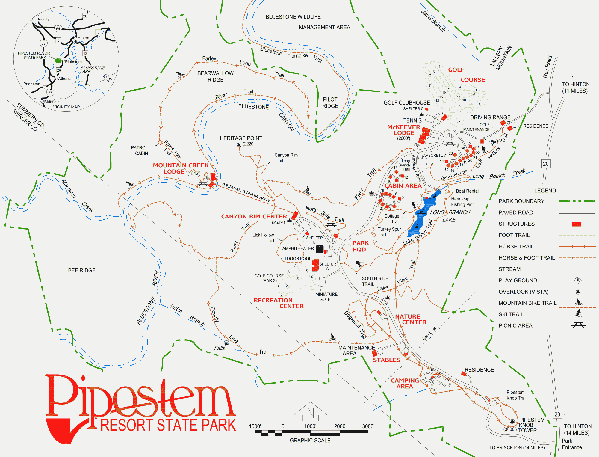
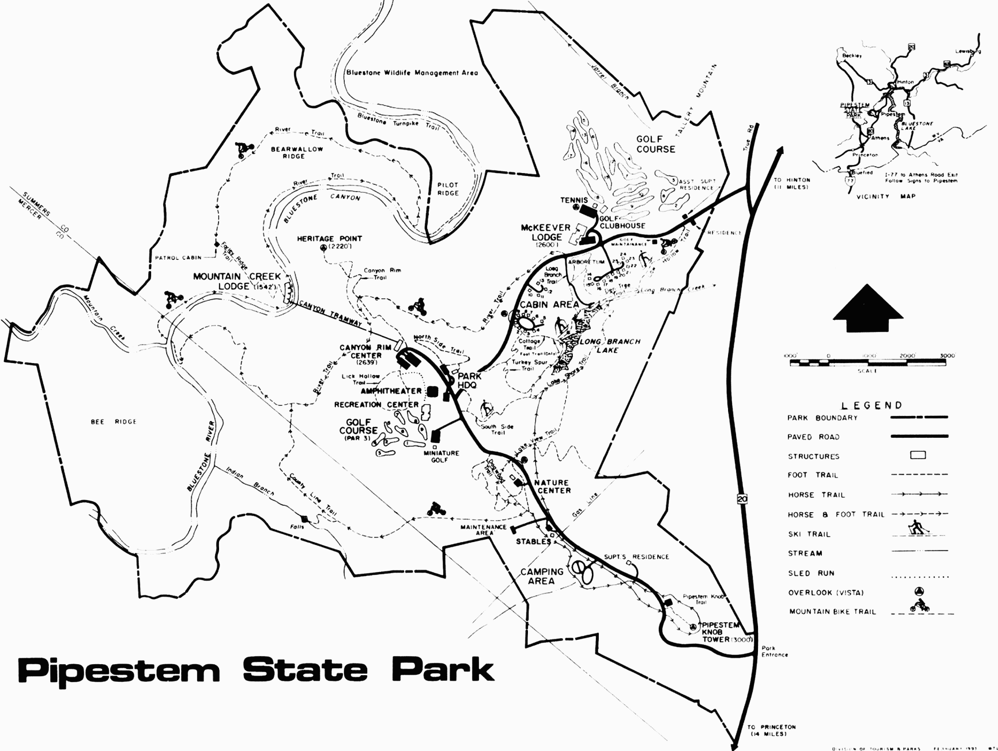
Spanning 16 square kilometres on the Mercer-Summers County border in West Virginia, Pipestem State Park is a crown jewel of Appalachia. Hiking, camping, mountain biking, boating, horseback riding, cross-country skiing, and sightseeing opportunities abound.
Geologically speaking, much of Pipestem State Park spans a plateau called Knob Ridge. Portions descend into the canyon of the Bluestone River, straddling Bearwallow Ridge and Pilot Ridge on the river's west side. The name "Pipestem" was taken from a nearby unincorporated community on Pipestem Creek, a tributary of the Bluestone River. The park officially opened on 25 May 1970, after two years of previewed phase openings and close to a decade of development.
![[Pipestem State Park aerial tramway]](transpo/ps-tram.jpg)
Aerial tramway at Canyon Rim Center, ca. 1998.
Funding for the project was provided by the Area Redevelopment Administration, a federal program initiated by the John F. Kennedy administration in 1961 to alleviate unemployment and stimulate interest in economically-depressed areas of the United States. Many of these areas were in West Virginia, which then as now was struck by poor infrastructure and the crutch of a destructive, coal-focused economy. The ARA's impact on the state was soon reinforced by further "Great Society" reforms to increase equity, reduce poverty, increase happiness, and improve the quality of life, including the Civil Rights Act (passed above then-racist senator Byrd's filibuster in 1964), and the founding of the Appalachian Regional Commission.
The advent of Pipestem State Park thus fit into the context of humanism, optimism, and dedication to public investment that prevailed in West Virginia at the time, best described by author John Alexander-Williams in the 1984 volume West Virginia: A History:
By 1971 the public-works program of the past few years had raised public expectations about the scope and quality of government services, while the end of the economic decline bolstered faith in the state's ability to finance further improvements. [...]
The 1971 session emerged as one of the most productive of the twentieth century. Its output contained something for everyone: a labor-relations act of the type that organized labor had sought since 1941; a civil-rights act that banned housing and job discrimination; more money for roads, schools, legislators, and teachers; measures that reformed the state's drug laws and lowered the voting age to 18; extensions of the civil service; and new regulations governing mine safety and air pollution. [...]
The period produced a few outstanding projects or measures: the workmen's compensation law of 1969, a luxurious new state park—Pipestem in Summers County, innovative high schools in a number of counties, an architecturally distinctive public library at Clarksburg, a record-shattering highway bridge over New River Gorge. [...]
By almost any standard of measurement, West Virginia had drawn perceptibly closer to national norms, and this was important. [...] Most West Virginians were tired of a limelight that showed only blemishes; even those who were most critical of the state's continuing deficiencies sometimes longed to be thought of as typical, ordinary, normal Americans. In 1971 these feelings did not seem so unrealistic as they had in earlier years. For most people it was a time of satisfaction and optimism, a well-deserved and long-awaited moment.
This context is so far removed from the present day that it might as well have been another world. Yet in spite of privatization threats in the twenty-first century...Pipestem State Park still exists. And while my time in West Virginia was blemished by the sense of frustration and anger I endured in the closet...some of my happiest moments in the 1980s, 1990s, and 2000s were spent in this park.
One of the many points of appeal of Pipestem State Park was its consistent and informative system of signage. During the 1980s these consisted primarily of trapezoid-shaped engraved wood signs, mounted to squat posts. Signs for hiking trails had arrowheads colour-keyed to the blaze colour (see below). The same template was also used for road signage throughout the park:
![[Pipestem State Park wooden signs, ca. 1980s]](transpo/ps-signs.png)
1980s Pipestem State Park signs; re-creation from memory.
In about the mid-1990s, the park's signage practices changed. Engraved wood regulatory and warning signs were phased out and replaced by conventional reflective road signs on tall posts, in the interest of both visibility and MUTCD compliance. Newer trail and minor roadside signs continued to be made of engraved wood as before; however, the park switched from a trapezoidal template to a rectangular template in this era and became inconsistent about the use of colour-keyed arrowheads.
Most of the original trapezoidal trail signs succumbed to rot and replacement by the mid-2000s, and I'd be shocked if any of them were still in place at the park today. Since the 2010s (if not earlier), West Virginia state parks have been installing replacement signs made out of a synthetic composite material, rather than wood.
Any discussion of Pipestem's park signage can't be complete without a discussion of its colourful hiking trail blaze system. In the 1980s, 1990s, and 2000s, these blazes were rectangular, painted on tree trunks at eye level. These have since been supplemented or replaced by diamond-shaped plastic blazes nailed to trees.
![[Pipestem State Park trail map]](transpo/ps-blazemap.png)
Hiking trail blaze colours in Pipestem State Park.
Pipestem's system is strangely reminiscent of Florida's colour coding system for U.S. highways. The blaze colours appear to have been selected semi-randomly, with the only firm rule being that no trails of the same colour may cross (unless the forks are continuations of the same path). Even so, the different blaze colours took on correlated associations in my mind. Blame it on imagination, or synesthesia crossing the wires of my brain...
But now I'm getting off-track...
The links below provide detailed information on each hiking trail, its physical characteristics, its context, and its history. Several of Pipestem's hiking trails follow the courses of former vehicular roads and highways, and historical maps of each trail's routing are provided whenever applicable.
Note: Please take all the coordinates and measurements on this page with a grain of salt. There are discrepancies between the hiking trail lengths given in different "official" sources; whenever this happens, I've erred towards the longer or more precise measurement. All elevation figures are approximations calculated from Open Street Map.
Generally, hiking trails built from old roadbeds are accessible to mountain bikers; other trails are not...but there are exceptions. Always defer to official sources for determining acceptable trail uses.
These hiking trails are arranged in rough increasing order of distance from the park entrance:
![[trailhead sign]](transpo/ps-knobsign.png)
![[trailhead sign]](transpo/ps-countysign.png)
![[trailhead sign]](transpo/ps-dogwoodsign.png)
![[trailhead sign]](transpo/ps-lakeviewsign.png)
![[trailhead sign]](transpo/ps-southsign.png)
![[trailhead sign]](transpo/ps-northsign.png)
![[trailhead sign]](transpo/ps-lickhollowsign.png)
![[trailhead sign]](transpo/ps-canyonsign.png)
![[trailhead sign]](transpo/ps-turkeysign.png)
![[trailhead sign]](transpo/ps-cottagesign.png)
![[trailhead sign]](transpo/ps-riversign.png)
![[trailhead sign]](transpo/ps-longbranchsign.png)
![[trailhead sign]](transpo/ps-servicesign.png)
![[trailhead sign]](transpo/ps-lakeshoresign.png)
![[trailhead sign]](transpo/ps-dentreesign.png)
![[trailhead sign]](transpo/ps-lawhollowsign.png)
![[trailhead sign]](transpo/ps-farleysign.png)
![[trailhead sign]](transpo/ps-horsesign.png)
![[Home]](home.gif) The Network
The Network![[Forward]](forward.gif) Hiking Trails
Hiking Trails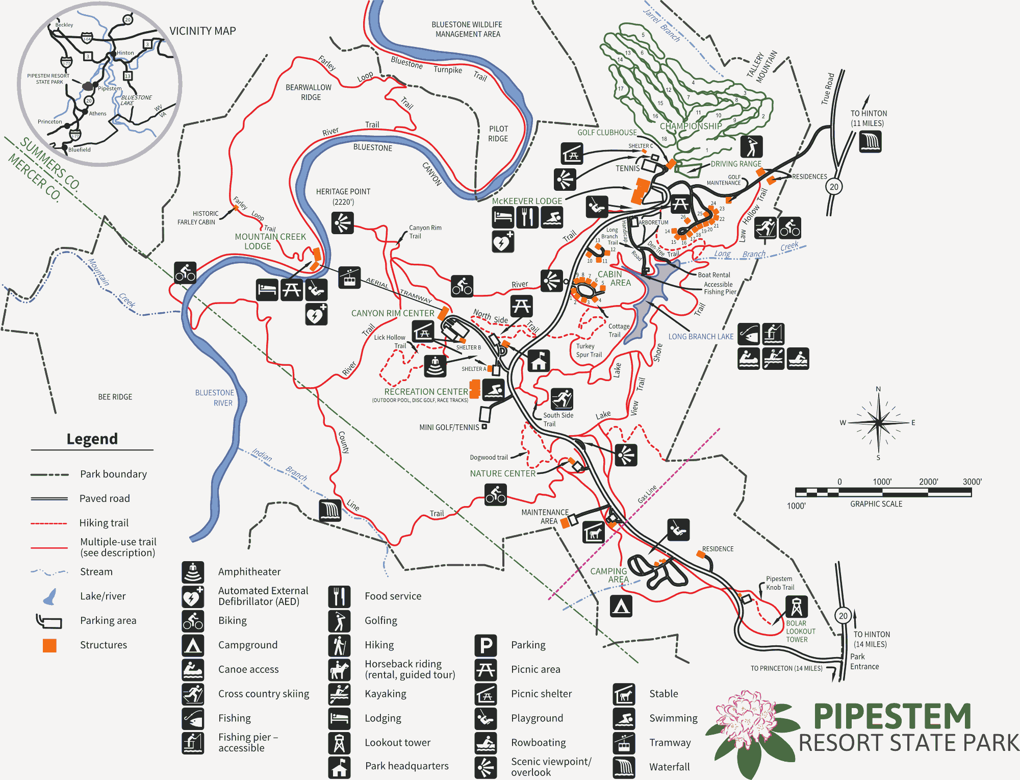